Lịch Thủy triều Việt Nam
4.1


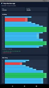
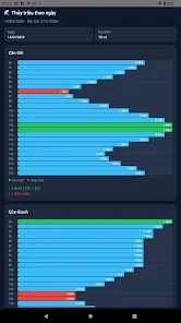
Lịch Thủy triều Việt Nam helps you check daily tide levels along the Vietnamese coast, presenting hourly water heights, daily highs and lows, and lunar calendar information. Designed for fishermen, boaters, coastal residents and anyone planning activities by the sea, the app lets you pick a Gregorian date, view the corresponding lunar day, and compare multiple stations side by side. A search box and filters make it easy to select one, several or all locations. Visual 24-hour graphs show water level in meters and the times of peak and low tides, helping with timing and safety near shore.
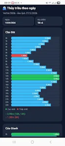
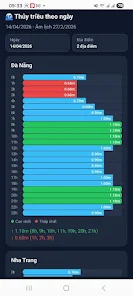
⭐ Hourly water level graphs for each station, displayed as a 24-hour chart in meters.
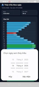
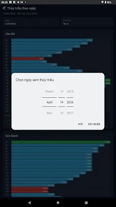
⭐ Select any Gregorian date and view the matching lunar calendar day within the same screen.
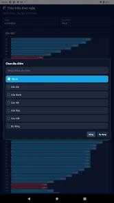
⭐ Filter and search to pick one, multiple, or all coastal locations quickly.
⭐ Each location shows the highest and lowest tide levels of the day along with corresponding time frames.
⭐ Lịch Thủy triều Việt Nam presents a clear visual summary for easy comparison between stations.
✅ Intuitive interface that puts hourly charts and daily extremes at a glance.
✅ Ability to compare multiple locations helps with route planning and activity timing.
✅ Lịch Thủy triều Việt Nam combines Gregorian and lunar calendar views for convenient reference.
✅ Search and filter tools reduce the time spent finding the exact station you need.
❎ Focused on tide levels only; it does not provide weather, wind or sea state information.
❎ Displays a 24-hour graph per selected date and location, rather than multi-day trend charts.